- We are referred to as Shxwhá:y I.R. #5 by all official governments.
- We hold joint title to Skulmalasph I.R. #16 and Grasslands I.R.#15.
- We are located adjacent to City of Chilliwack.
- We are north of the Chilliwack River and east & south of the Fraser River.
- Shxwhá:y is situated west of Coco-Oppelo Slough.
- Our Village comprises an area of approximately 670 acres.
- We are located within Stó:lō/ Ts’elxwéyeqw traditional territory.
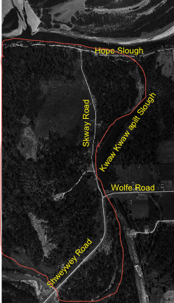 This is an aerial view of Shxwhá:y Village taken in 1954. Note there is no Band Office and only 2 homes. (red line is approx. reserve boundary. Reaches to Fraser to the west.)